∴
The Monarch Line District
Independence and Maple Plain · abstract, mock-up plan, legend and measured footage plan · working draft, September 2026
Abstract
Maple Plain’s neighborhoods end at the roundabout on US 12. West of it is Independence: fields, Lake Irene, horse farms, and the Twin City Polo Club a mile south on Turner Road. The Monarch Line district is a plan for what grows there when a train stops at the roundabout. It is a horse-country village built for families, drawn so that the fields stay fields and the town gets the things it has always had to drive for.
The station sits at a civic core, not in a parking lot: an activity center with a rink, a pool, a gym and a climbing wall; city hall; police; a state services office. Within a ten-minute walk are townhomes, small apartment buildings of four to sixteen units, shops on Main Street, a village green, a Christian school, church campuses, and the Marisol Center for women’s health, prenatal care, maternity housing and family support, with pediatrics and childcare, and housing beside it for the nurses who staff it. Beyond that walk the lots get larger, not smaller: estate lots of five to ten acres with barns and paddocks, a twenty-acre horse farm, an equestrian center with an indoor arena and trailer parking, and bridle trails to the polo club and the Luce Line horse trail. At Lake Irene, an outdoor campus with a camp, a gun range and a raptor center. Parking is in pockets of forty to fifty cars, plus a small paid park-and-ride pad at the station; there is no free lot. The Pioneer Creek marsh, the lake shore and the working farm are not developed.
The Monarch Line is the rail line through the district: west along the Luce Line corridor through Watertown, Winsted and Hutchinson to Cosmos, and by a branch up the Highway 55 corridor to Cold Spring and St. Joseph, with prairie strips of milkweed and native grass on both sides of the track. The exact route north is under study and will be compared on this page. The district is the worked example for the proposal’s land-use compact: every town on the line writes its own station-area rules before a line is drawn.
Mock-up plan
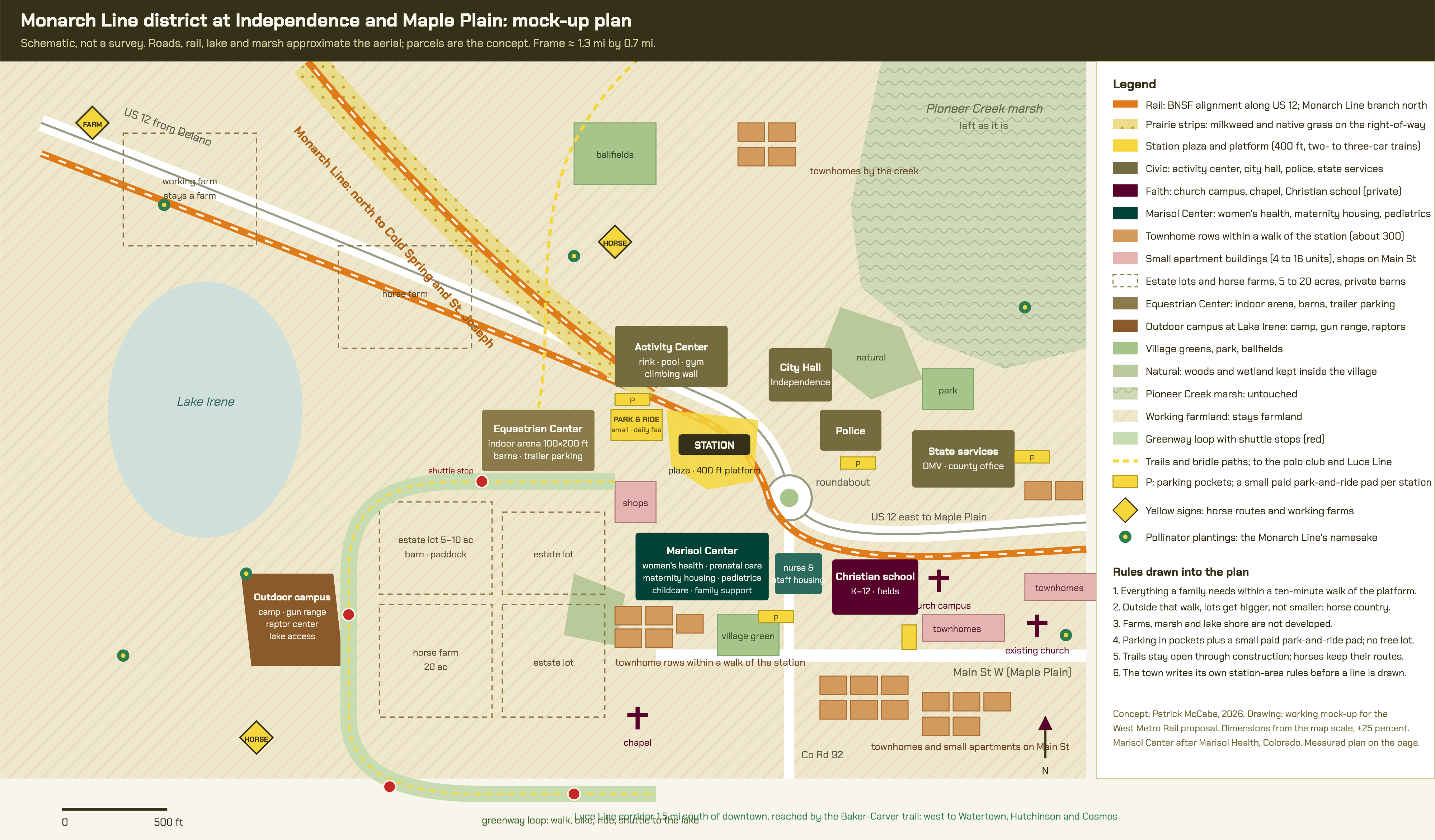
Legend
| On the plan | What it is |
|---|---|
| Orange line | Rail. The line along US 12 follows the BNSF alignment east to Long Lake, Wayzata and Minneapolis; the branch to the north-west is the Monarch Line toward Cold Spring and St. Joseph. |
| Gold band on the branch | Prairie strips on the right-of-way: milkweed and native grass, the habitat the line is named for. |
| Yellow plaza with STATION | Station plaza and a 400-foot platform for two- or three-car trains, between the Activity Center and City Hall. |
| Olive buildings | Civic: Activity Center (rink, pool, gym, climbing wall), City Hall, Police, state services (DMV and a county office). |
| Dark red buildings and crosses | Faith: church campus, chapel, existing church, and a private Christian school (K to 12, with fields). |
| Dark green building | The Marisol Center, modeled on Marisol Health in Colorado (Catholic Charities of Denver): women’s health and prenatal care, ultrasound, counseling, maternity housing and family support, with pediatrics and childcare; nurse and staff housing beside it. |
| Small tan squares | Townhome rows within a walk of the station (Patrick’s blue hatch). |
| Pink blocks | Townhomes and shops on Main Street. |
| Dashed outlines | Estate lots of 5 to 10 acres and a 20-acre horse farm, each with its own barn and paddock. |
| Brown building | Equestrian Center: indoor arena 100 by 200 feet, barns, horse-trailer parking. |
| Brown block at the lake | Outdoor campus: camp, gun range, raptor center, lake access. |
| Green squares | Village green, park, ballfields. |
| Pale green shapes and wave pattern | Woods and wetland kept inside the village; the Pioneer Creek marsh, untouched. |
| Straw hatching | Working farmland: stays farmland. |
| Light green loop with red dots | Greenway loop for walking, biking, riding and a shuttle to the lake; red dots are shuttle stops. |
| Yellow dashed lines | Trails and bridle paths, including the route south to the Twin City Polo Club on Turner Road and to the Luce Line horse trail. |
| Yellow bars marked P | Parking pockets of 40 to 50 cars beside buildings, and a small paid park-and-ride pad at the station. No free lot. |
| Yellow diamond signs | Horse routes (HORSE) and working farms (FARM). |
| Green dots with yellow centers | Pollinator plantings scattered through the district. |
Rules drawn into the plan
- Everything a family needs is within a ten-minute walk of the platform.
- Outside that walk, lots get bigger, not smaller. This is horse country and stays horse country.
- Farms, the marsh and the lake shore are not developed.
- Parking is in pockets plus a small paid park-and-ride pad at each station. Polo match crowds and school events arrive by train and shuttle.
- Trails stay open through construction and horses keep their routes.
- The town writes its own station-area rules before a line is drawn.
Where the district sits on the corridor
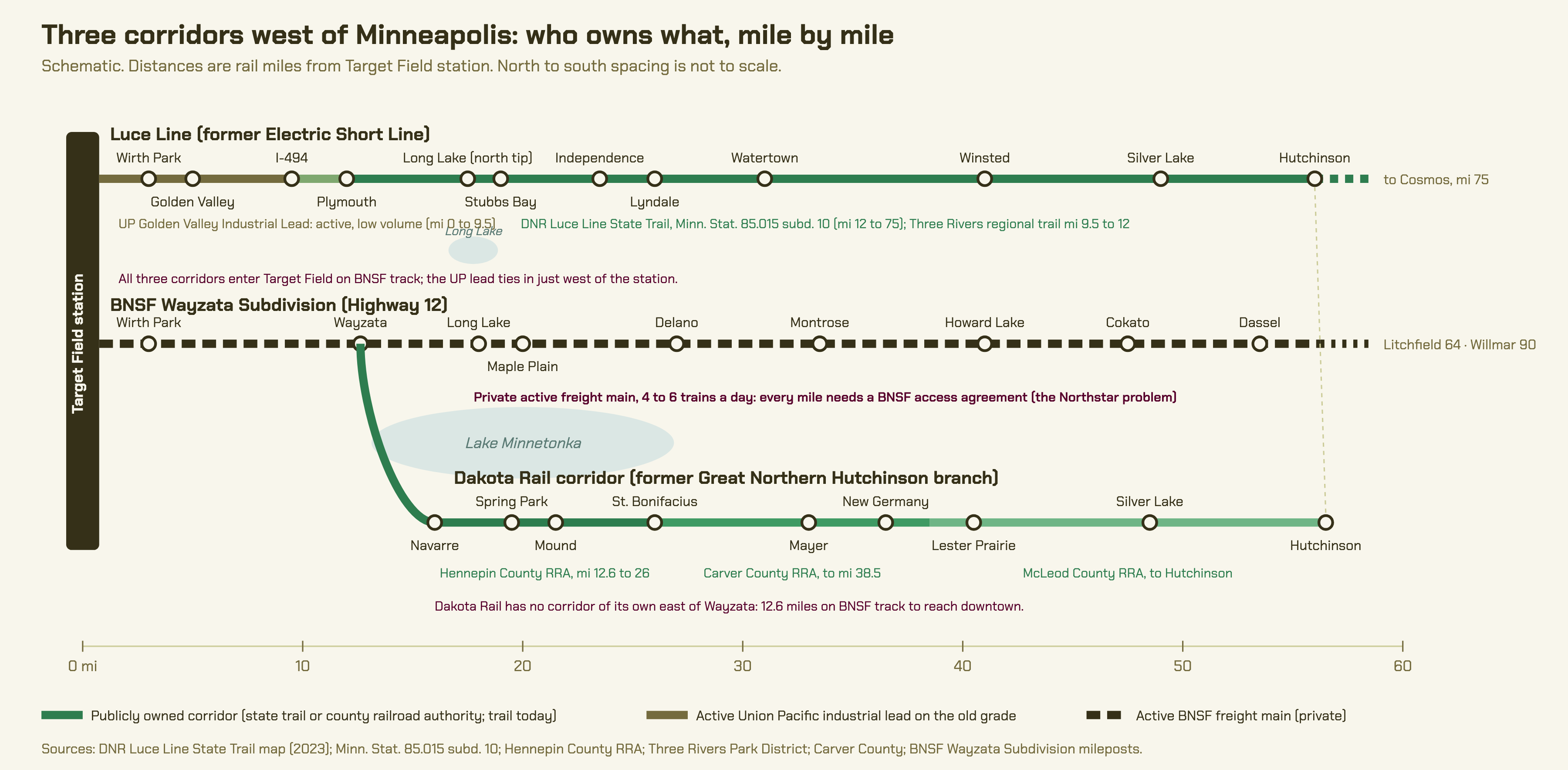
The concept places the station on the BNSF alignment through the roundabout, which is the Highway 12 corridor in the comparison below. The Luce Line State Trail runs about a mile and a half south of downtown Maple Plain, and the Baker-Carver Regional Trail already links the two along Budd Avenue (OpenStreetMap geometry, checked 27 September 2026; an earlier version of this page placed the trail to the north). That is a corridor-choice input, not a settled decision: a downtown station argues for the Highway 12 line or a short spur from the Luce Line, and against a station out on the state trail.
Measured footage plan
Measured from the original map file on 27 September 2026. The map’s scale bar puts 500 feet at 130 pixels, so one pixel is 3.85 feet and the frame is 7,690 by 4,940 feet, about 1.46 by 0.94 miles, or 870 acres. Every drawn color was classified pixel by pixel and grouped into shapes; solid shapes are accurate to about ±10 percent. Hatched townhome areas are given two ways, by neighborhood footprint (an overestimate) and by drawn coverage (an underestimate).
Patrick’s key, confirmed. Purple is multi-family and the number is units per structure. Blue hatch is townhomes. Yellow P is parking. Maroon is pre-existing buildings kept. Grey is civic. Brown is natural land and the outdoor campus. Light green is parks and the greenway. Red B is a shuttle stop. Orange is rail. Yellow diamonds are horse and farm signs; green flowers are pollinator plantings.
| Use | Acres | What it holds |
|---|---|---|
| Civic (grey) | 10.1 | DMV 3.95, Religious Charter school 1.91, City Hall 1.21, Police 0.86, Activity Center about 1.0, one unlabeled strip 0.8 |
| Multi-family (purple) | 8.3 | 10 buildings; labeled 10, 10, 5, 5, 5, 5 units; unlabeled blocks at 9 units per acre; about 72 units in all |
| Townhomes (blue hatch) | 60.7 footprint / 6.9 drawn | Seven neighborhoods; 250 to 400 townhomes; 300 is the working number |
| Existing buildings kept (maroon) | 6.7 | Seven buildings, the largest 2.0 acres north of the highway |
| Parks and greens (light green) | 27.8 | Greenway loop band 7.8, Park G north 5.3, park at the roundabout 3.0, and eight smaller greens |
| Natural inside the village (brown) | 4.4 | Four wetland and woodland pieces left alone; the outdoor campus marker at Lake Irene is 3.9 acres more |
| Parking (yellow P) | 4.6 | About 550 stalls at 120 per acre; the four signs are excluded |
| Station wedge (orange) | ≈ 7 | Platform, plaza, shuttle loop and the small paid park-and-ride pad; base about 690 feet, height about 940 feet |
| Marisol Center and nurse housing | ≈ 1.5 | Modeled on Marisol Health: women’s health and prenatal care, ultrasound, counseling, maternity housing, family support |
| Shuttle stops (red B) | – | About 15 drawn on the greenway loop and the east loop |
| Not drawn on | ≈ 730 | Fields, Lake Irene, the Pioneer Creek marsh and the existing neighborhoods east of Meadow Lane stay as they are |
| Use | Parcel | Width × height (ft) | Acres |
|---|---|---|---|
| Civic | DMV | 731 × 377 | 3.95 |
| Civic | Religious Charter school | 462 × 354 | 1.91 |
| Civic | City Hall | 223 × 392 | 1.21 |
| Civic | Police | 377 × 200 | 0.86 |
| Civic | Grey strip south of Main St (unlabeled) | 577 × 154 | 0.82 |
| Civic | Activity Center (rink, pool, gym, climbing wall) | 254 × 277 | 0.71 |
| Civic | Activity Center (west part) | 223 × 177 | 0.25 |
| Multi-family | MF-1 north block, 10 units | 246 × 246 | 1.14 |
| Multi-family | MF-2 L-shaped block east of Main St | 338 × 362 | 1.14 |
| Multi-family | MF-3 east block by Henry St | 238 × 362 | 0.96 |
| Multi-family | MF-4 south row, 10 units | 231 × 238 | 0.87 |
| Multi-family | MF-5 triangle at station | 231 × 262 | 0.75 |
| Multi-family | MF-6 south of Main St | 308 × 169 | 0.73 |
| Multi-family | MF-7 south row, 5 units | 146 × 238 | 0.66 |
| Multi-family | MF-8 south row, 5 units | 146 × 246 | 0.65 |
| Multi-family | MF-9 south row, 5 units | 138 × 246 | 0.59 |
| Multi-family | MF-10 south row, 5 units | 115 × 238 | 0.58 |
| Multi-family | MF-2 L-shaped block, second piece | 69 × 146 | 0.19 |
| Existing building | North (industrial area) | 238 × 462 | 2.04 |
| Existing building | South of Main St | 446 × 238 | 1.69 |
| Existing building | By the station (west) | 169 × 300 | 0.90 |
| Existing building | South (Crest) | 254 × 146 | 0.73 |
| Existing building | South 2 | 254 × 108 | 0.50 |
| Existing building | At the roundabout | 338 × 169 | 0.42 |
| Existing building | At the roundabout 2 | 192 × 154 | 0.40 |
| Park / green | Greenway loop band (west) | 669 × 1831 | 7.84 |
| Park / green | Park G north | 515 × 492 | 5.27 |
| Park / green | Park G at the roundabout | 977 × 338 | 2.97 |
| Park / green | Green east with horse sign | 331 × 915 | 2.94 |
| Park / green | Green with B-loop (east) | 554 × 608 | 2.47 |
| Park / green | Green east strip | 231 × 554 | 1.59 |
| Park / green | Green south | 377 × 285 | 1.18 |
| Park / green | Green south-west | 315 × 254 | 0.96 |
| Park / green | Green far east | 277 × 338 | 0.87 |
| Park / green | Green G south of Main | 238 × 169 | 0.77 |
| Park / green | Green far east 2 | 223 × 392 | 0.58 |
| Park / green | Small green (unlabeled) | 115 × 85 | 0.19 |
| Park / green | Green with B-loop, second piece | 162 × 262 | 0.18 |
| Natural / outdoor | Outdoor camp, gun range, raptor center (marker) | 538 × 585 | 3.91 |
| Natural / outdoor | Natural (northeast, by Police) | 815 × 831 | 1.90 |
| Natural / outdoor | Natural (west of Main St) | 315 × 415 | 1.37 |
| Natural / outdoor | Natural (center) | 246 × 292 | 0.78 |
| Natural / outdoor | Natural arc (northeast) | 554 × 115 | 0.34 |
| Parking | P long bar by Religious Charter | 585 × 146 | 1.19 |
| Parking | P at the station | 185 × 400 | 0.62 |
| Parking | P at the roundabout | 146 × 215 | 0.39 |
| Parking | P north (by existing building) | 169 × 108 | 0.37 |
| Parking | Eleven pockets of 0.12 to 0.26 acre each | 62 to 238 across | 2.0 |
| Neighborhood | Footprint (ft) | Acres (bounding box) |
|---|---|---|
| TH-1 south-west, along the greenway | 1400 × 669 | 21.5 |
| TH-2 east, Henry St to Meadow Ln | 900 × 1008 | 20.8 |
| TH-3 center, west of Main St and the Marisol Center | 669 × 962 | 14.8 |
| TH-4 far south-west | 169 × 638 | 2.5 |
| TH-5 by Lake Irene (B stop) | 154 × 115 | 0.4 |
| TH-6 by Lake Irene 2 | 146 × 100 | 0.3 |
| TH-7 by Lake Irene 3 | 100 × 146 | 0.3 |
| Total footprint | 60.7 |
Two numbers to sit with. First, the drawing adds roughly 370 homes (about 300 townhomes and 72 apartments) beside a city of about 700 households, which is why the program will be phased and why sewer capacity is the first engineering question. Second, the station wedge and the parking together cover about 12 acres, more than the civic buildings; that is where the paid park-and-ride pad and the shuttle loop earn their keep by keeping the pads small.
Parking rule, as instructed. Each station gets a small park-and-ride pad with a small daily fee, never a free lot. The fee funds upkeep and the shuttle. Pockets beside buildings stay.
The east half: downtown Maple Plain
A second map arrived on 27 September 2026 covering downtown Maple Plain east of the first one: from Meadow Lane and Three Oaks Avenue on the west to Baker Park Road on the east, Perkinsville Road on the north and Maple Airport on the south. Its scale was set from two downtown intersections located in OpenStreetMap, Budd Avenue at Main Street East and Baker Park Road at Independence Street: 3.3 feet per pixel on the 2,800-pixel file, good to about 3 percent. The frame is about 1.75 by 1.25 miles. Together the two maps cover the whole district and overlap for about 900 feet along Meadow Lane.
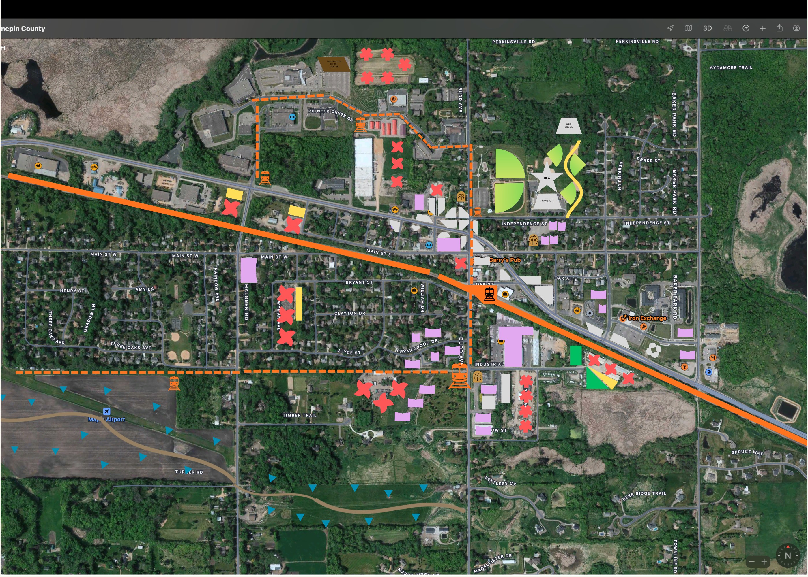
What the drawing places: the station at the center of downtown on the BNSF alignment, where Budd Avenue crosses Main Street East and Oak Street; a dashed loop with train icons running north up Budd Avenue and west along Pioneer Creek Drive through the industrial park, and a second dashed line south along the Timber Trail latitude to the fields by the airport, read as a local circulator; a star-shaped recreation center with lawns and fields beside City Hall, and a preschool to the north; a Wahpekute Tribal Center at the north edge by the industrial park; multi-family blocks scattered through downtown and the south side; parking bars; a trail by the recreation center; and a green and yellow gateway wedge where the highway enters town from the east.
| Use | Acres | Shapes |
|---|---|---|
| Rail line, station and circulator loop (orange) | 18.2 | 95 |
| Civic and kept buildings (grey) | 13.3 | 48 |
| Multi-family (pink) | 10.5 | 23 |
| Red X marks and red flowers (meaning to confirm) | 9.4 | 25 |
| Parks and lawns (green) | 7.2 | 7 |
| Parking and trail (yellow) | 2.7 | 5 |
| Blue triangles in the fields (meaning to confirm) | 2.1 | 25 |
Four symbols still need Patrick’s key. About twenty red X marks on existing buildings and sites; a dozen red four-petal flowers in the north and south fields and the industrial park; about forty blue triangles in rows across the fields by Maple Airport; and a brown curving band through the south fields. Until he says what they mean they are measured but not programmed.
The whole district on one map
Both drawings are placed on real ground here. The west map is pinned to the US 12 roundabout at 3.85 feet per pixel and the east map to the downtown grid at Budd Avenue at 3.31 feet per pixel, so the two overlap along Meadow Lane and read as one district about three miles long, from Lake Irene to Baker Park Road. The views below are stills from the interactive map, with the drawings at 85 percent so the ground shows through. Click any of them to open at full size.
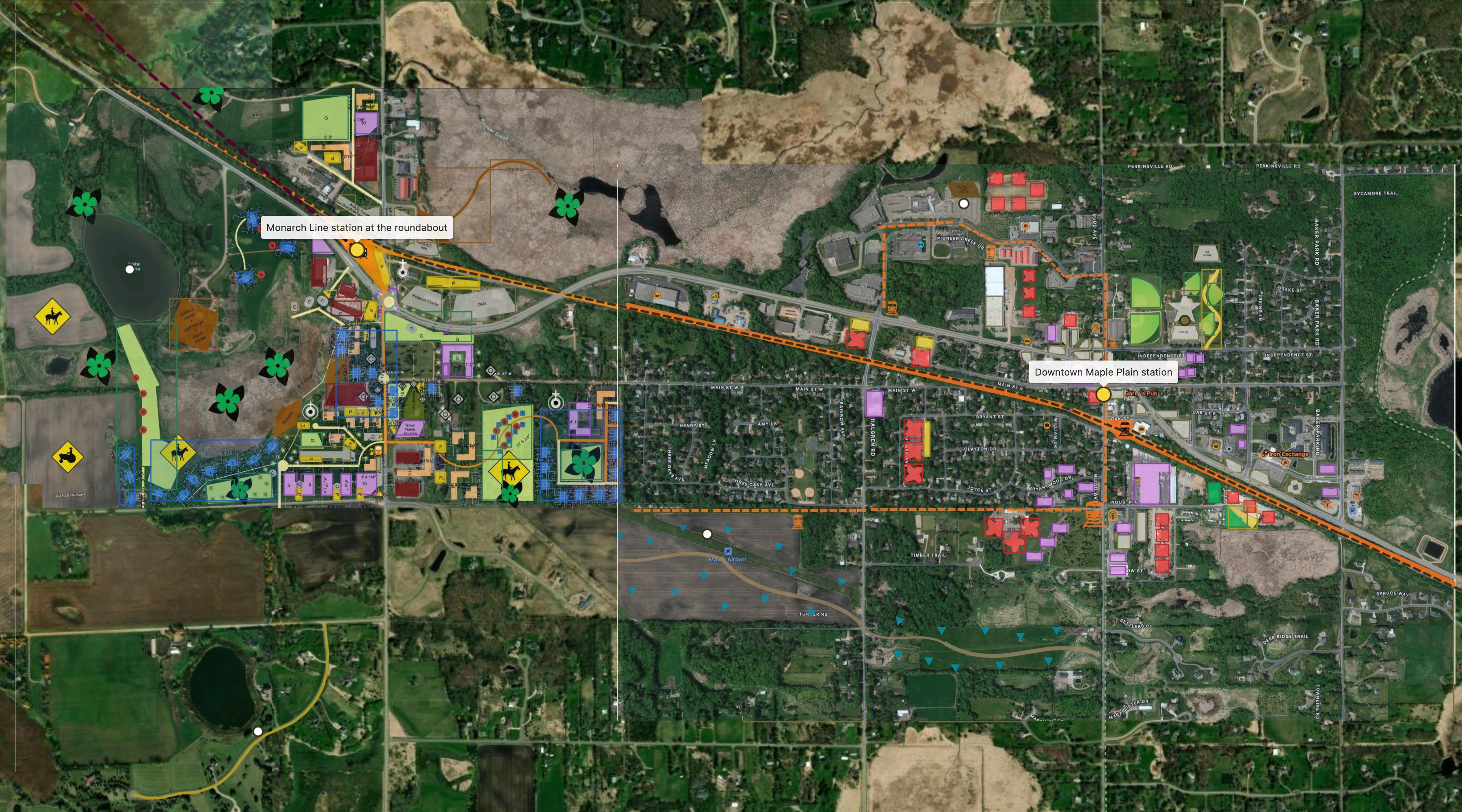
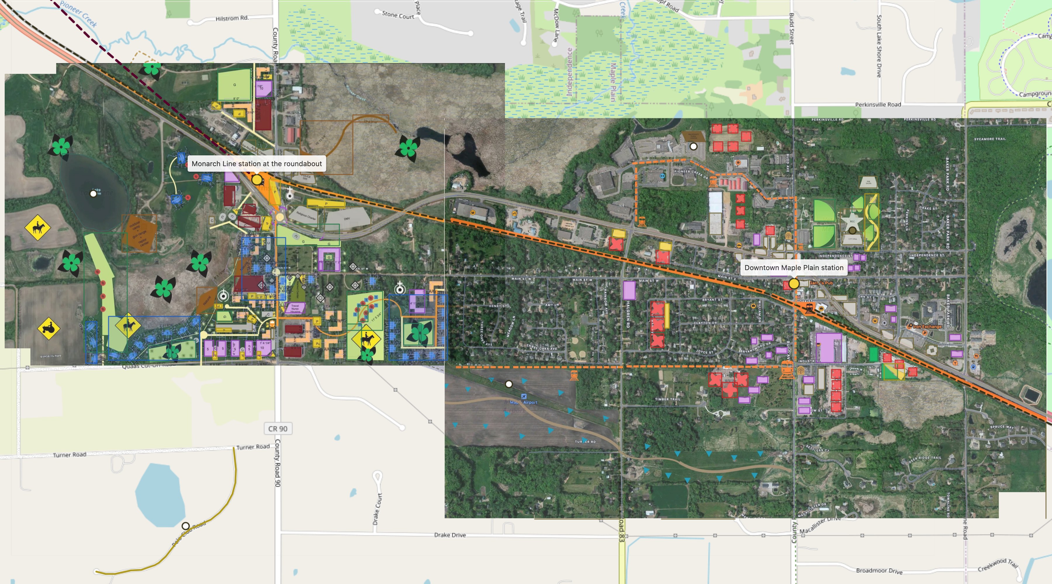
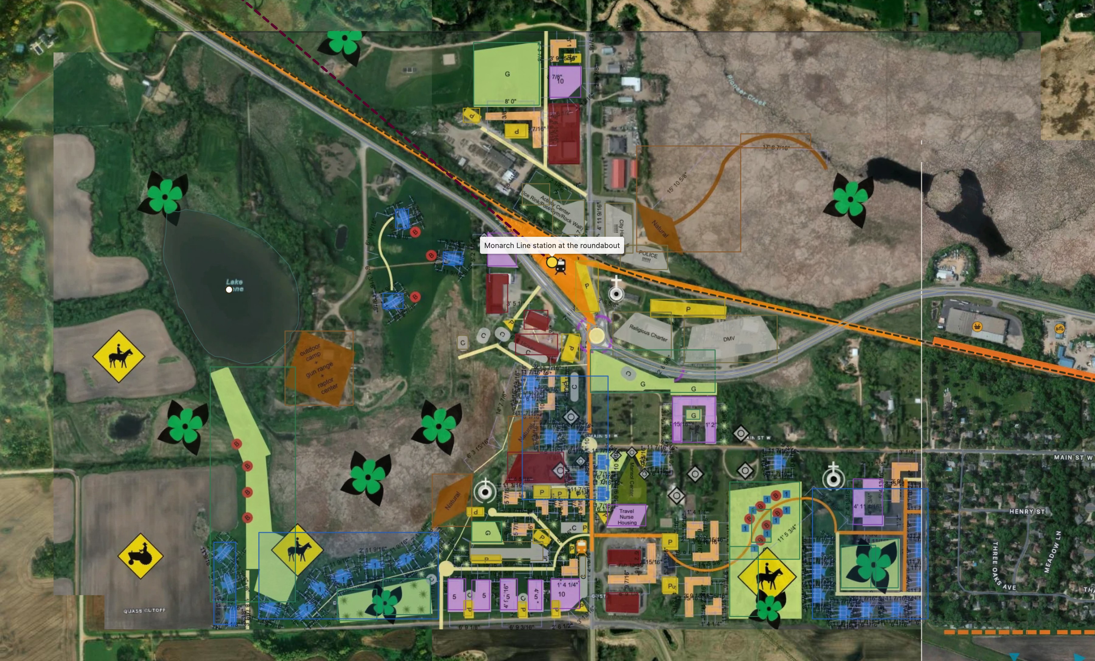
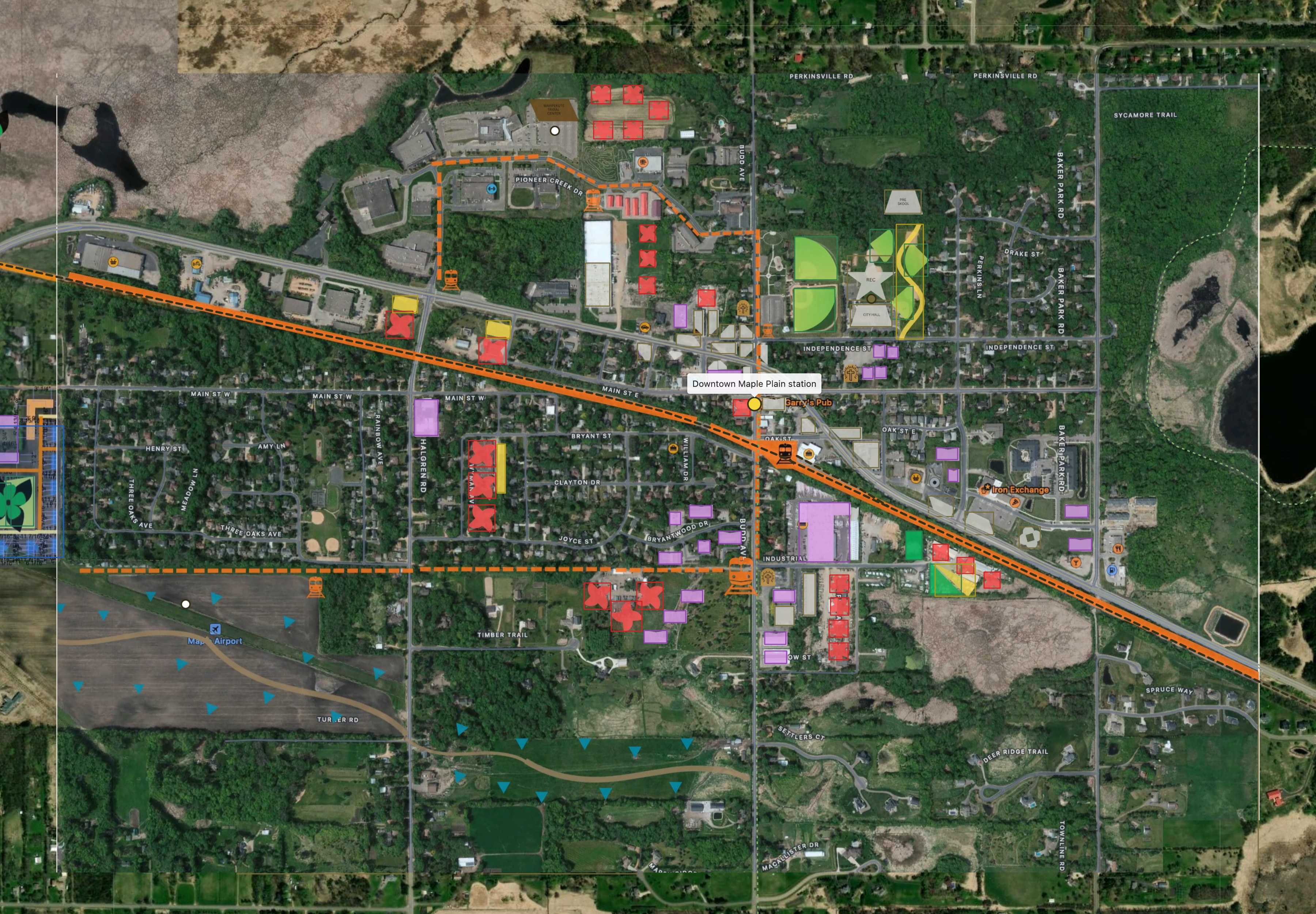
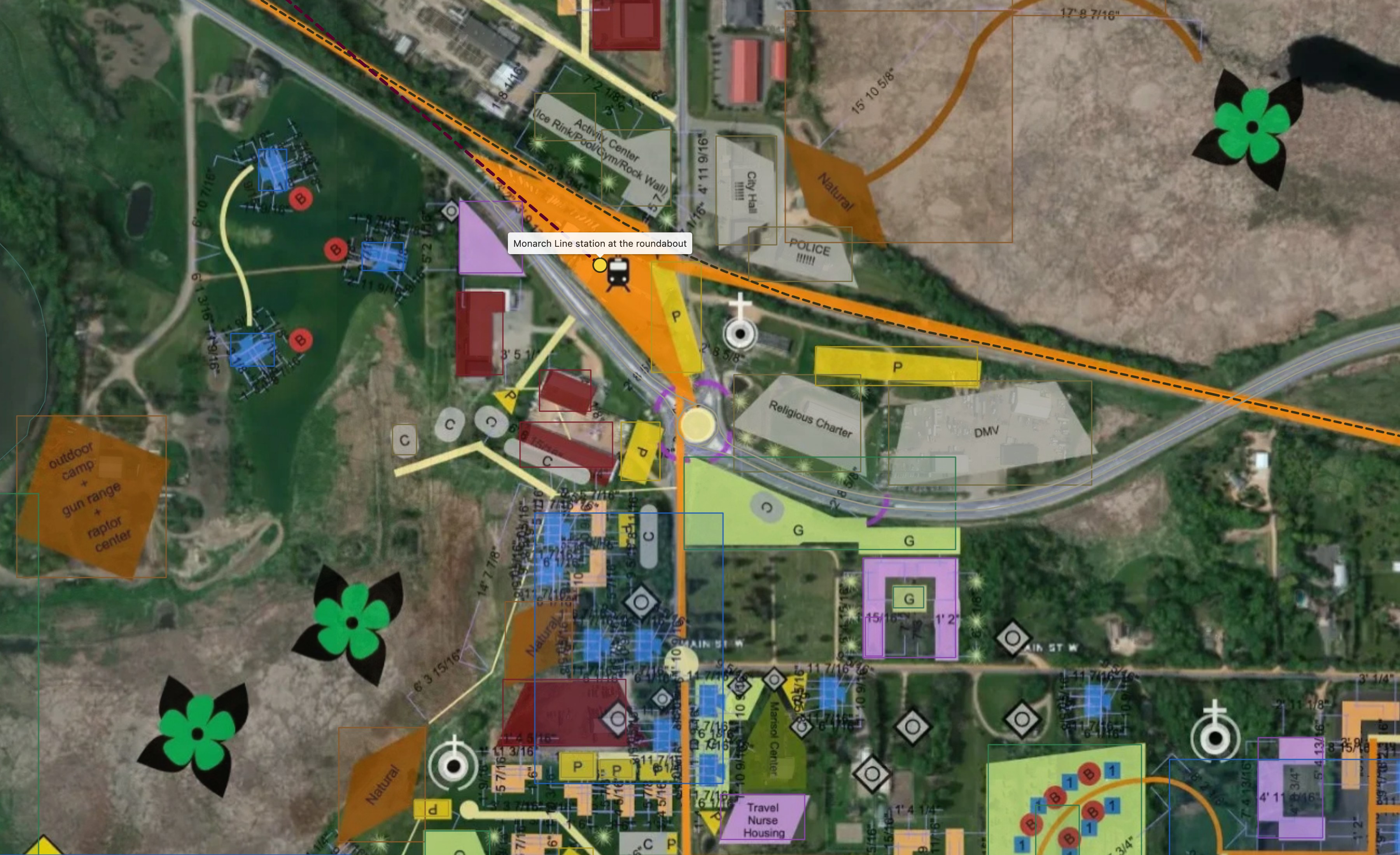
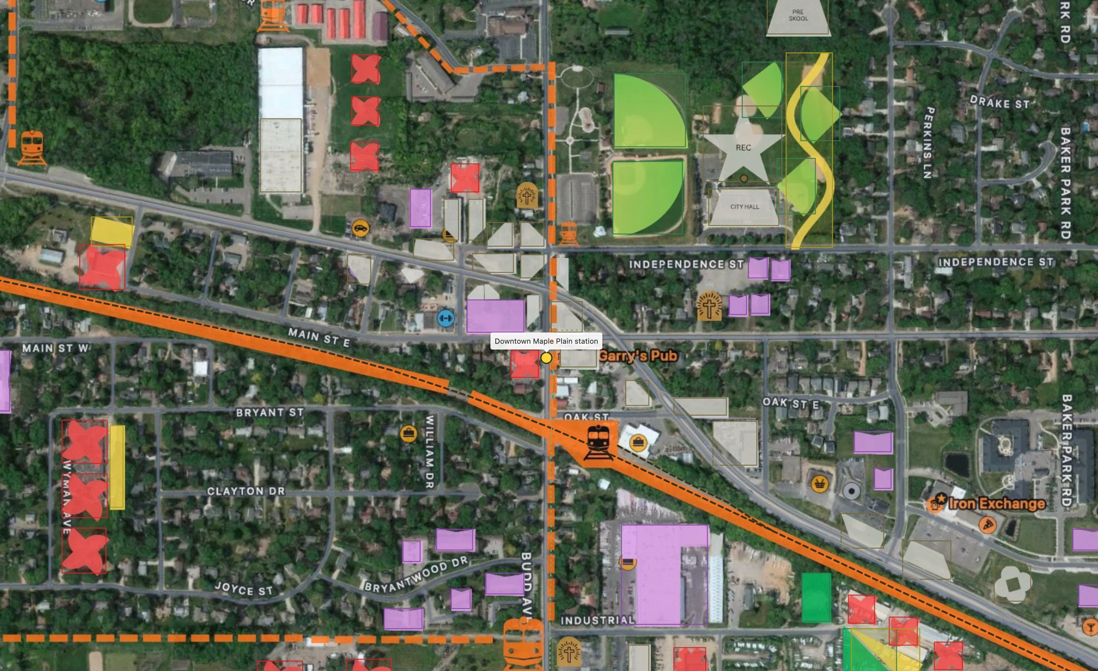
The interactive version. The same map pans and zooms, lets you click any measured parcel for its acreage, switches between aerial and street views, and fades either drawing in or out. This site does not run map scripts, so it is hosted separately and will be linked from here.
Imagery © Esri and partners; street map data © OpenStreetMap contributors; drawings © Patrick McCabe, 2026. Each drawing is pinned by known intersections and its own scale; expect errors of a few percent across a drawing.
Design notes
On “luxury.” Inside the coalition the word says what you mean: quality, permanence, craft. In a council chamber in Independence it reads as exclusion and higher taxes. The plan says “estate district” and “village” in public and reserves “luxury” for the marketing of homes, where buyers expect it.
On families. The Marisol Center, the school, the churches and the family-sized homes state the town’s values in the affirmative: this is a place that welcomes children. The plan does not define the district against Minneapolis. A contrast reads as a campaign line and invites a fight the town does not need; the affirmative reads as a choice the town made.
On the word “sprawl.” The proposal’s whole case is that rail lets towns grow without sprawl. What is drawn here is the anti-sprawl version of growth: a compact village at the platform, horse country beyond it, farmland and marsh untouched. Large lots for horses are the open space, not the sprawl, as long as the compact holds.
On the school. Minnesota charter schools must be nonsectarian, and the 2025 Supreme Court split left that rule in place. The plan therefore shows a private Christian school. A nonsectarian classical charter is the alternative.
On taxes. The money model is a public-private cooperative, as instructed: no new general taxes and no county railroad levy. The public partners bring the corridor, permits, planning and existing transit funds; a member-owned cooperative of landowners, developers, businesses, towns and riders carries construction and operations through development value, memberships and private capital. The proposal will say plainly what private capital has and has not built in American regional rail.
Decisions recorded, 27 September 2026
- Blue hatch is townhomes.
- Numbers on the purple blocks are units per structure.
- The Marisol Center follows Marisol Health in Fort Collins and Greeley, Colorado.
- The Monarch Line runs the Luce Line to Cosmos, with a branch up Highway 55 to Cold Spring and St. Joseph.
- Maroon buildings are pre-existing and kept.
- No new taxes: the money model is a public-private cooperative, not a levy.
- The original map file was supplied and measured.
- Each station gets a small park-and-ride pad with a small daily fee.
Coming next on this page
The development program built on the measurements above: buildings, floor area, homes, parking and the ratios used, with costs; the station, equestrian and Marisol Center programs; the Monarch Line route north, segment by segment, with owners and obstacles; the public-private cooperative money model; phasing; and the risks. Research on Maple Plain’s existing conditions, the polo club, the churches, the route north and the cooperative model is in progress. A link to the interactive map will be added once it is hosted, and the four unkeyed symbols on the east map will be programmed once their meaning is confirmed.

